애국으로행복

[스크랩] `독도는 朝鮮땅` 명시된 日정부 공식地圖 발견

good해월 2015. 7. 17. 08:04
//


'독도는 朝鮮땅' 명시된 日정부 공식地圖 발견

  • 양승식 기자

    이 기자의 다른 기사 보기


    입력 : 2015.04.14 03:00 | 수정 : 2015.04.14 06:53

    1897년 제작 '대일본제국全圖'
    日 아닌 한국영토로 색깔 구분… 이름도 '竹島' 대신 러式 표기

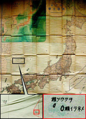
    일본 농상무성이 1897년 제작한 '대일본제국 전도'. 울릉도와 독도를 자신들의 영토가 아닌 '조선'의 영토로 표시했고, 이름도 일본명인 '죽도'가 아니라 러시아식 명칭인 '올리부차, 메넬라이'라고 썼다. /이덕훈 기자
    독도가 우리나라의 영토임을 명시한 일본 정부의 공식 지도가 국내 연구진에 의해 발견됐다. 일본이 최근 독도가 자기 고유 영토라는 주장을 중학교 교과서와 외교청서(外交靑書)에 확대 재생산하고 있는 상황에서 일본 정부 스스로 독도가 자국 영토가 아님을 공식 시인한 증거가 나온 것이다.

    호사카 유지 세종대 독도종합연구소장은 13일 "독도를 한국 땅으로 명시하고, 일본 땅이 아님을 시인한 일본 농상무성(農商務省)의 1897년 '대일본제국전도'가 최근 발견됐다"며 "그동안 독도를 한국 땅으로 인정한 민간 지도는 발견됐지만, 일본 정부가 이를 시인하는 내용을 담은 지도가 발견된 것은 처음"이라고 말했다.

    호사카 교수가 이날 공개한 지도는 농상무성이 1897년(메이지 30년) 직접 제작한 일본 전도(全圖)다. 이 지도에서 한반도와 울릉도·독도를 자신들의 영토로 표시하지 않고 하얀색의 '조선(朝鮮)' 영토로 표시했다. 특히 독도는 자신들이 주장했던 죽도(竹島)가 아니라 러시아식 명칭인 올리부차(독도 서도)와 메넬라이(독도 동도)로 표기했다. 반면 당시 시모노세키조약에 의해 일본 식민지가 됐던 대만은 자신들의 영토로 표시했다.

    호사카 교수는 "일본이 독도를 1905년 강제 편입할 때 내·외무성과 농상무성이 주도적 역할을 했다"며 "당시 농상무성이 독도가 어업적 측면에서 중요하다고 주장한 것이 받아들여졌기 때문"이라고 말했다. 일본 농상무성은 현 일본 농림수산성과 경제산업성의 전신이다. 호사카 교수는 "지금까지 일본 정부의 공식 지도에는 독도가 빠져 있었기 때문에 일본 측이 독도를 자국 영토라고 주장할 일말의 여지가 있었지만, (이번 지도 발견으로) 아베 정부의 '고유 영토' 주장은 명백한 허위임이 밝혀졌다"고 했다.


    [출처] 본 기사는 조선닷컴에서 작성된 기사 입니다


    Official Japanese Map Identifies Dokdo as Korean

    On this Japanese government map from 1897, Dokdo and Ulleung islands are labeled as Korean territory. On this Japanese government map from 1897, Dokdo and Ulleung islands are labeled as Korean territory.

    Researchers here have discovered an official Japanese government map that identifies the Dokdo islets as Korean territory.

    The latest discovery adds to a mounting body of evidence debunking Japan's flimsy colonial claim to the Korean islets that is increasingly being pushed in Japanese school textbooks.

    Prof. Yuji Hosaka of Sejong University said Monday the map from the Japanese Agriculture and Commerce Ministry from 1897 "clearly identifies Dokdo as part of Korean territory."

    Hosaka said most proof so far has come from civilian maps, but this is the first government map that has been found.

    The map shows Dokdo and Ulleung islands along with other Korean territories and refers to them by their Russian names instead of Japanese ones. In contrast, the map identifies Taiwan as Japanese territory because it was under colonial rule at the time.

    "When Japan annexed Dokdo in 1905, the Interior Ministry, Foreign Ministry and Agriculture Ministry played leading roles," Hosaka said. "The Agriculture and Commerce Ministry felt Dokdo was important in asserting Japan's fishing rights."

    Hosaka added, "Since Dokdo hasn't been included in official Japanese maps, this made it difficult for Tokyo to lay claim to the islets. The discovery of the latest official map clearly shows the Abe administration's claims are groundless."


    //
    출처 : 대한민국 박사모 (박사모)
    글쓴이 : 독도평화33 원글보기
    메모 :